Datasets for AutoBOP
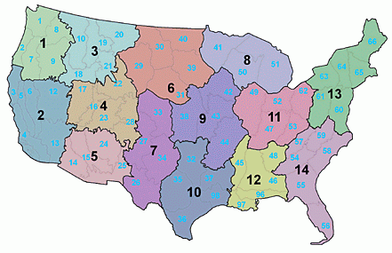
Datasets for infiltration, impervious cover, and overland roughness have been prepared for the continental United States. The datasets are available in arcgrid format for use with Autobop or they can be loaded through the Tools | Import parameter menu item. The impervious cover and overland roughness datasets are broken up into 14 regions for the continental United States as shown in the following figure.
Infiltration Parameter Maps
- Effective Porosity (unitless)
- Saturated Hydraulic Conductivity (in/hr)
- Wetting Front Suction Head (in)
- Soil Depth (in)
Impervious Cover Maps
| Zone 1 | Zone 5 | Zone 9 | Zone 13 |
| Zone 2 | Zone 6 | Zone 10 | Zone 14 |
| Zone 3 | Zone 7 | Zone 11 | |
| Zone 4 | Zone 8 | Zone 12 |
Overland Roughness Maps
| Zone 1 | Zone 5 | Zone 9 | Zone 13 |
| Zone 2 | Zone 6 | Zone 10 | Zone 14 |
| Zone 3 | Zone 7 | Zone 11 | |
| Zone 4 | Zone 8 | Zone 12 |