Creating Filter Files
When importing distributed data of different resolutions or projections, creating a filter file may be necessary. Filter files effectively filter data to a common grid definition. In Vflo™, filter files are called BAG files because they bear the file extension *.bag, which stands for Basin Average Grid. Filter file use may include:
- In Vflo™, a filter file may be used to filter rainfall files to the grid definition of the Vflo™ domain.
- In Continuous Simulator, a filter file may be used to filter rainfall files to the grid definition of the Vflo™ domain.
- In Inundation Analyst, a filter file may be used to filter stage files to the grid definition of the flow direction maps and DEM being used.
Step-by-step instructions
Creating a filter file in Vflo™
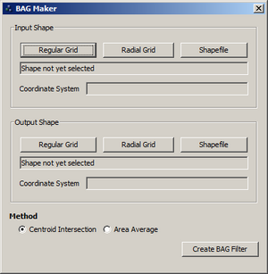
Filter files can be created in Vflo™ using the BAG maker tool.
1. Open Vflo™.
- Select Tools | BAG Maker.
2. BAG Maker allows the user to select 3 different types of input and output domains.
- Regular Grid used for rectangular domains (i.e. Vflo domains or Gridded Rainfall)
- Radial Grid used for radar data in polar coordinates.
- Shapefile used for irregularly shaped polygons.
-
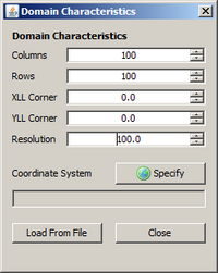
The Regular Grid option allows the user to input directly the number of columns, rows, x lower left coordinate, y lower left coordinate, and resolution. The user must select a coordinate system that defines the domain. Also, the domain can be defined using either an bopx file or an ESRI ASCII file.
-
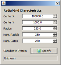
The Radial Grid option allows the user to define the center of a polar coordinate system, radius of the coordinate system, number of radials, and number of gates. The user must also select a coordinate system that will be used with the center coordinates.
-
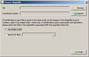
The Shapefile option allows the user to select an existing polygon shapefile to define the domain. If the polygon shapefile has a projection file (.prj) associated with the shape then BAG maker will read it directly. If the shapefile does not have a projection then the projection must be selected manually.
3. Select input and output domains using either grid, polar, or shapefile option.
4. Choose the filter method for bag file creation. Centroid performs a spatial join between the centroid of the input domain shapes and each of the output domain shapes. Thecentroid method is the fastest and most commonly used method. Area Average performs a weighted area average using each of the input shapes. This method can be more time consuming for larger areas.
5. Click on the Create BAG Filter button to finish the process.