Tutorial: Developing a Vflo™ model with GIS maps
This tutorial demonstrates how to import ASCII parameter maps into Vflo™ to design a basin model. The basin model will be saved as a BOP, or basin overland properties file (*.bopx, *.bop). Other options for building a Vflo™ model include using the AutoBOP tool, or developing a basin model directly within Vflo™ by drawing in flow direction arrows and manually establishing cell parameters.
For this tutorial, use Bray’s Bayou, TX sample data available at http://apps.vieuxinc.com/sampleData/Example_ASCII.zip. Alternately, the ASCII files exported in following the directions of the Formatting parameter maps in GIS page may be used. The files needed are listed in the table below.
Contents
Importing parameter maps
1. Start a new basin model.
- Select the Create a new file
 tool from the Vflo™ Toolbar.
2. The Domain Wizard will appear.
- Select Use ASCII File and click the Browse button located beneath the text Flow Direction Map.

- Navigate to \Vflo\ASCII\flow_direction.asc. Click Next.
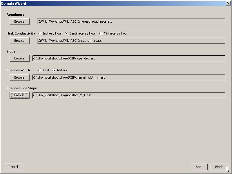
3. The second Domain Wizard window will appear.
- Click Browse under Roughness and navigate to \Vflo\ASCII\merged_roughness.asc.
4. Click Browse under Hyd Conductivity.
- Navigate to \Vflo\ASCII\ksat_cm_hr.asc or \Vflo\ASCII\ksat_in_hr.asc.
- Select the unit appropriate to the imported file: Inches, Centimeters, or Millimeters.
5. Click Browse under Slope.
- Navigate to \Vflo\ASCII\merge_slope.asc.
6. Click Browse under Channel Width.
- Navigate to \Vflo\ASCII\channel_width_meters.asc or \channel_width_feet.asc.
- Select the unit appropriate to the imported file: Feet or Meters.
7. Click Browse under Channel Side Slope.
- Navigate to \Vflo\ASCII\ch_2_1.asc. Click Finish. After processing is complete, the Main Display will show the resulting Vflo™ model.
8. If desired, infiltration parameter maps (wetting front, effective porosity, etc.) may be imported, as well.
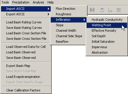
- For example, select Tools | Import ASCII | Infiltration | Wetting Front. Navigate to \Vflo\ASCII\wetting_front_suction_cm or \wetting_front_suction_in.asc. Click Open.
- Repeat for other parameter maps.
9. All imported parameter maps may now be saved as a single BOP file.
- Select the Save
 tool from the Vflo™ Toolbar. Browse to an appropriate save location, enter the desired File name and select Save.