RainVieux
 What is RainVieux?
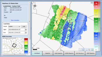
An interactive webpage is at the heart of RainVieux that allows the user to display, query, and download rainfall in near real-time products and end-of-month archival quality data. RainVieux provides quality-controlled rainfall data for municipal, private, and regional organizations basin-specific applications including watershed management, infiltration and inflow analysis, long-term capacity planning, and flood event analysis.
When running Vflo®, the RainVieux interface allows the query and display of simulated and observed hydrologic stage/discharge.
What is RainVieux?
An interactive webpage is at the heart of RainVieux that allows the user to display, query, and download rainfall in near real-time products and end-of-month archival quality data. RainVieux provides quality-controlled rainfall data for municipal, private, and regional organizations basin-specific applications including watershed management, infiltration and inflow analysis, long-term capacity planning, and flood event analysis.
When running Vflo®, the RainVieux interface allows the query and display of simulated and observed hydrologic stage/discharge.
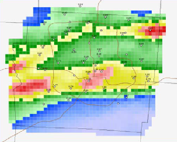
Gauge-adjusted Radar Rainfall (GARR)
RainVieux data consists of gauge and radar input processed for bias correction, quality control, and filtered to user-specific grids, catchments or basins in model-ready format.
Depth Duration Frequency Analysis (DDF)
RainVieux can support DDF display for the relative frequency of rainfall events in addition to intensities. Frequency is determined based on the depth and duration of rainfall events. The recurrence or return interval is useful for evaluating the pattern and distribution of rainfall.
 Features & Benefits
- Accessible Rainfall - Display, query, and download quality-controlled data.
- Accurate Rainfall - A combination of rain gauge and weather radar giving the most accurate rainfall maps.
- Depth Duration Frequency - Map the most intense rainfall return interval at specified durations.